
The old aerial lighthouses of the USA: gadgets that revolutionized aviation
The First World War was the first armed conflict in which aviation had a notable importance in various missions..
On May 15, 1918, before the end of the war, the United States launched a civilian airmail service, initially running a route between Washington DC, Philadelphia, and New York. Facing its expansion throughout the rest of the country, this airmail system encountered a serious problem: the lack of light.

Nowadays, night flights are very common thanks to the modern navigation aids available to aircraft, but the old airplanes had great difficulties flying at night with the rudimentary technology that existed in the late from the 1910s and early 1920s. Due to the enormous size of the US, stopping flights from dusk to dawn meant slowing down airmail considerably, making it not a serious competitor with rail mail. Likewise, day flights also needed navigational aids.

The first US attempts to facilitate air navigation at night began in 1921, when the Army installed rotating beacons between Columbus and Dayton (Ohio) covering a distance of 80 miles (128 km) , with what the aviators could do that route at night, observing the beacons at intervals of 10 seconds.

In 1923, the US Congress approved the creation of an airway called the Transcontinental Airway System (Transcontinental Airway System), which would cross the country from New York, on the east coast, to San Francisco, on the west coast. This airway covered a distance of 2,665 miles (4,288 kilometers) , traversing some mountainous and other desert areas.

The objective of this transcontinental airway is that the planes could cover routes between dawn and dusk. On this route, beacons were mounted on 16-meter towers with rotating lights atop (each beacon made six rotations per minute), spaced 3 miles (4.8 km) apart between each beacon , being smaller the separation in the mountainous zones. The light from the beacons had a range of 10 miles (16 km). In total, between 1923 and 1927, the US Post Office Department installed 616 aerial beacons between New York and San Francisco. 89 emergency airfields and 18 terminal airfields were also built.
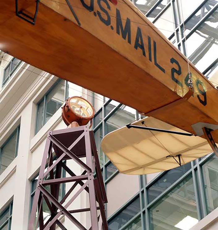
This system of airway beacons revolutionized airmail in the United States, and was also used in Europe (where the beacons were known as aerial lighthouses). In addition to the light towers, it was they built concrete arrows that indicated to the aviators the position of the next beacon on that air route.

The visual aid system reached 1,500 aerial beacons nationwide by the early 1930s. However, due to rapid advances in the aircraft industry, by the late 1930s, In the 1920s, radio navigation aids began to replace aerial beacons. Little by little, the old beacons were being abandoned. At present many of these aerial lighthouses have disappeared, others are in ruins and some are still preserved, even being active in certain mountainous areas, mainly in the states of Idaho and Montana.
In this video by Aaron Kunz you can see an aerial beacon hovering active in Dubois, Idaho:
In this other video from SoCal Outdoor Explorer we can see an aerial beacon in ruins in Santa Clarita (California):
Bibliography:
- "Fad to Fundamental: Airmail in America". National Postal Museum.
- "Transcontinental Service". National Postal Museum.
- "Beacons". National Postal Museum.
- "Airway Beacons—Western United States". Roger Barnes.
- "Airmail Beacon". National Postal Museum.
---
Main image: Aaron Kunz.
|
Don't miss the news and content that interest you. Join Explorando for free on Telegram: Click here to join |
- Most read
- The supermassive black hole of Phoenix A, the biggest known light-devouring monster
- A graveyard of British red telephone boxes in the middle of a forest
- The huge crevasse that starts at a ghost town in a desolate area of Utah
- Forest City, a large ghost town filled with skyscrapers on the coast of Malaysia
- The last of the German rescue buoys that floated in the North Sea in World War II
- Exploring the Caspian Sea Monster: the abandoned Lun ekranoplane in Dagestan
- The Electra del Lima, an abandoned jewel of northern Portugal's industrial past


Opina sobre esta entrada: