
Sandy: the enigma of a ghost island that appeared on the maps of the Pacific Ocean
 ES
ESExplorations have discovered new lands for hundreds of years, which have been successively mapped. Sometimes in that process strange things happen.
In November 1774, the famous English explorer James Cook described an island located west of New Caledonia, in the southern Pacific Ocean, naming it "Sandy Island". He included it in the document with his discoveries that he published two years later.
One hundred years later, a ship sailing from Australia, the "Velocity", saw what looked like a sandy island and named it Sandy Island. From then on, the island began to appear on various maps of various countries, with a surface area larger than that of Manhattan Island. The island should not arouse great interest, since for many years its place on the map practically only served for ships to avoid it, in order not to run aground on it.
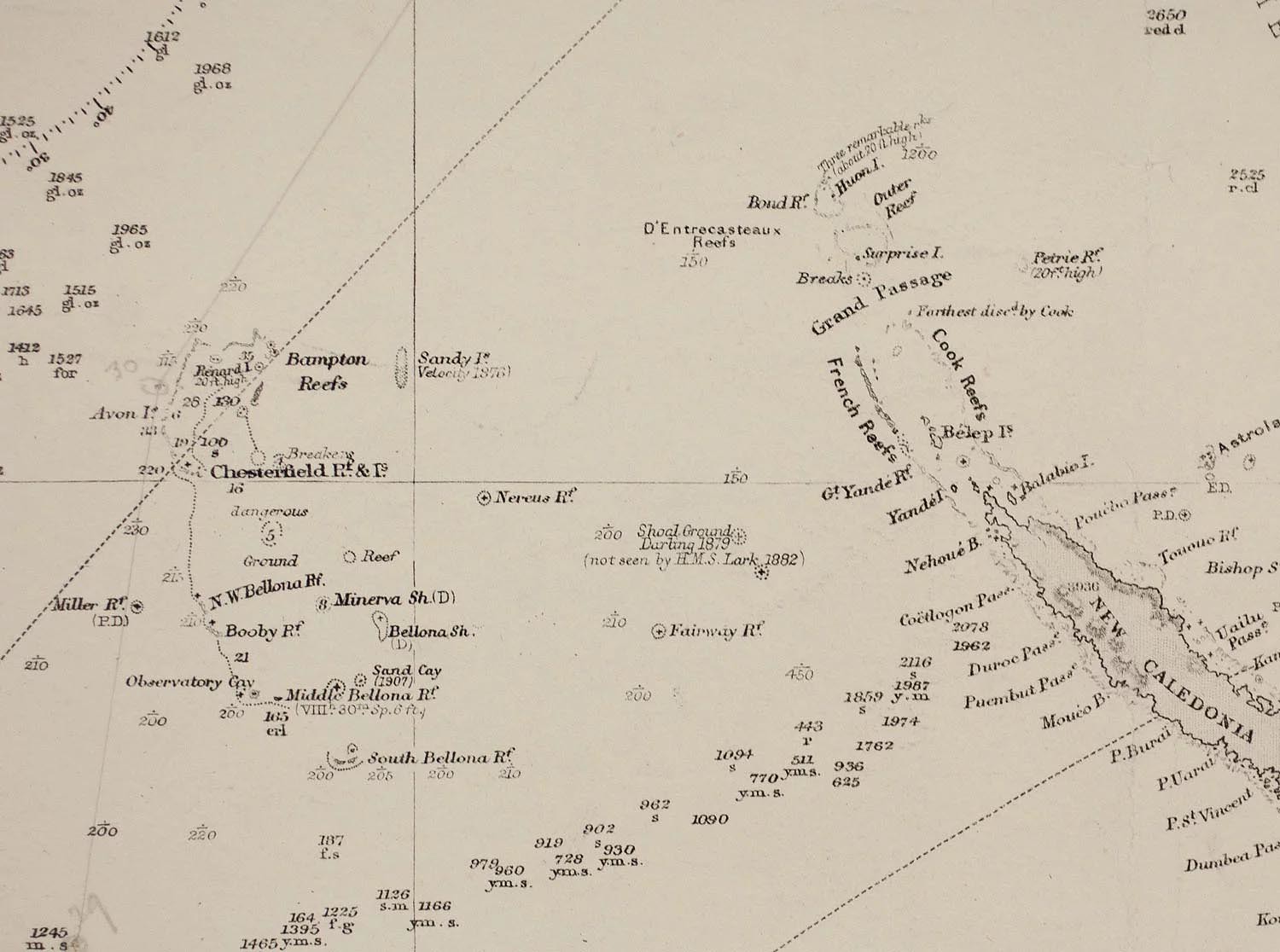
With the advent of satellite photos, the island disappeared from many maps, because nothing appeared in the place where it was supposedly located. Paradoxically, Sandy Island continued to appear on maps and even on Google Maps and Google Earth until 2012, when an expedition of radio amateurs looking for places without radio emissions found, when navigating to that point, that there was nothing there. In fact, in the place where many maps fixed the location of that island, the depth of the ocean exceeds 1,400 meters.

The origin of the supposed island is to this day an enigma. Some believe that Cook confused it with the Chesterfield Islands, or that perhaps both he and the Australian ship that thought they saw it a century later ran into each other, actually, with a floating pumice surface.
What is worth asking is how, in the age of artificial satellites, this phantom island continued to be indicated on the maps. That it happened in the time of James Cook, when cartography was not as exact as it is today, is somewhat explainable, but it is shocking that the myth continued to exist until 2012, and even more so in the case of a supposed island larger than Manhattan.

The reasonable question that we can now be left with is: How many smaller islands that appear on maps in remote places could also be ghost islands? That does not necessarily mean, of course, that they never existed. An island that was little more than a sandbar may have been wiped out by a volcanic eruption or hurricane. For example, in 2016 the disappearance of five islands of the Solomon archipelago was reported.
---
Image: National Geographic.
|
Don't miss the news and content that interest you. Receive the free daily newsletter in your email: Click here to subscribe |
- Lo más leído
- A large collection of Volkswagen cars hidden in an abandoned mine in Switzerland
- The supermassive black hole of Phoenix A, the biggest known light-devouring monster
- An old Soviet military plane abandoned from 1971 on a Russian island near Alaska
- The 'Bomber Glacier': The wreckage of a B-29 on a remote mountain of Alaska
- The unknown Soviet female cosmonaut who died on a mission: history or hoax?
- The Krak des Chevaliers, a great Crusader fortress that was conquered by deception
- A desert in which three strategic bombers from the Cold War are abandoned


Opina sobre esta entrada: